Monday, November 27, 2006

culture shock: embracing the issue

fault line = open wound
buildings = sutures [how do you treat the wound]

suture
n.
The process of joining two surfaces or edges together along a line by or as if by sewing. The material, such as thread, gut, or wire, that is used in this procedure.
The line or stitch so formed.
Medicine. The fine thread or other material used surgically to close a wound or join tissues. The stitch so formed.
Anatomy. The line of junction or an immovable joint between two bones, especially of the skull.
Biology. A seamlike joint or line of articulation, such as the line of dehiscence in a dry fruit or the spiral seam marking the junction of whorls of a gastropod shell.
tr.v., -tured, -tur•ing, -tures.

Buildings are projected in the earthquake planes on each side of the fault line. Connections are made from one side to the other as and earthquake occurs. grow. stretch. close. connect. link. Sections slide from the permanent structure and begin to bridge the gap across the fault line. But like a wound, the fault line is numb, meaning that the shock from the quakes are absorbed. However, the city [of course somewhat resistant to an earthquake, like any city at risk strives to be] shakes with the earthquake. Flexible panels on the exterior of the structure wiggle/tremor during the earthquake.

Sunday, November 19, 2006

culture shock

Seismic cities are located in the intersections of planes created in my mappings. These planes are originated from the epicenters of earthquakes and extend in the direction of the movement of the tectonic plates according to time. Certain intersections are very dense, apparent by observing from a global scale. These specific locations pinpoint the hub of a city or a grouping of cities.

But what makes a "Seismic City?" The three main programs of the city are:
1] residential/commercial buildings to withstand the tremors of an earthquake. This two story house made of wood and stucco was built to withstand earthquake tremors measured at a magnitude of 6.7, the same magnitude as the reverberations recorded near the epicenter of the 1994 Northridge earthquake that caused a significant amount of damage to the city of Los Angeles [estimated 40 billion US dollars]
The housing as well as research stations are completely enclosed in the earthquake planes [instead of being built on the ground plane].

2] research centers to monitor seismic motion and projecting exaggerated vibrations and sounds during an earthquake. People that live in the city will be able to hear an earthquake as it occurs. The city will be dedicated to research facilities and seismic stations. When cities or urban areas are located on land, they monitor the movement under the earth's crust. However, when a city is located in the ocean, the research can be geared more toward water displacement, created waves, and vibrations underwater.
3] flexible transportation to link the outer "planes" of the city [since the hub is the only part where the building planes intersect]. However, one thought is that the the roles of the city and the transportation are reversed. If instead the transportation were static and the city were flexible, this could eliminate damage, but deeply impact physical communication within the city. The architecture would absorb the impact of the tremors, but the roads systems could be effected by the impact because they may be less grounded or structurally sound. Elizabeth Hickok created the city of San Franciso out of jello and studied the effects of a simulated earthquake to observe the possibilities.

Thursday, November 16, 2006

discovering the seismic city


The "seismic city" is formed in the intersection of time and direction of plate movement of earthquakes from each of the epicenters. The cities are grounded on the axes of the earthquake planes which house program in the city. People that inhabit the city don't live on the ground plane, but on the earthquake plane. The axes define the main transportation. The hub of the city is formed with a series of intersections of planes. Further, a flexible sheild shades the city and is able to withstand tremors of an earthquake.

Monday, November 13, 2006

Friday, November 10, 2006

maybe just coincidence...

About 1/3 of the world's megacities [cities with a population of 2 million or more] are located near fault lines. These areas are subject to repeat seismic activities and damages from earthquakes that have occured and will continue to occur. But, what if building MEGA can cause earthquakes? However, facts show that population [and thus megastructures or supercities] does not necessarily cause earthquakes to occur. People simply like to live along the coast and the coastline many times falls on or near a fault line. Referring to the supercontinent, think about where the current coastlines were before the continental drift. When the earth's crust began to break apart and shift, new coastlines were formed along the fault lines [the edges of the tectonic plates]. These areas of risk are now heavily populated and thus receive the most destructive impacts from earthquakes.

So it seems that fault lines have created areas prone to building and population explosion [ideal or asthetic living conditions] which are subject to destruction and may even cause earthquakes to be more frequent. How ironic!

These seismic cities, the megacities located near fault lines, which already exist, can be redesigned and new seismic cities can be built. I am proposing that these new seismic cities be built in areas of intersection [of time and direction of plate movement] created through my mappings. They have potential to be submerged cities where those intersections occur in the ocean.

But can we build a resistance to a natural disaster? Could a new solution stop the cycle of building and destruction and in a sense stop earthquakes from causing damage?

locating seismic cities

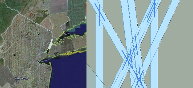
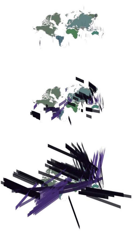
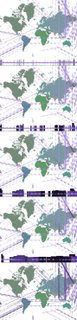
Fault lines are located at the edges of the tectonic plates, which are constantly in motion. Along these lines, the movement of the plates is made aware by the occurances of earthquakes. Because of these disasters and the physical and economical damage that they cause, there are seismic monitors that record the earth's reverberations and can even predict future occurances. The images include earthquake data over a period of 2 1/2 months. The fault lines, although not physically represented, start to appear by the earthquake patterns that occur over this short amount of time. Columns appear to grow from the epicenter of an earthquake. [the height of the column represents the magnitude of the earthquake measured by the Richter Scale 1-9.9] These columns extend in a plane depending on time since occurance and direction of tectonic plate movement at each specific location. When you look at the mappings, notice the high frequency of earthquakes in the Southeast Asian area specifically.
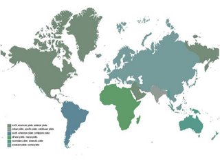
[basemap for the earthquake mappings showing each tectonic plate by color]

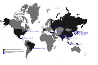
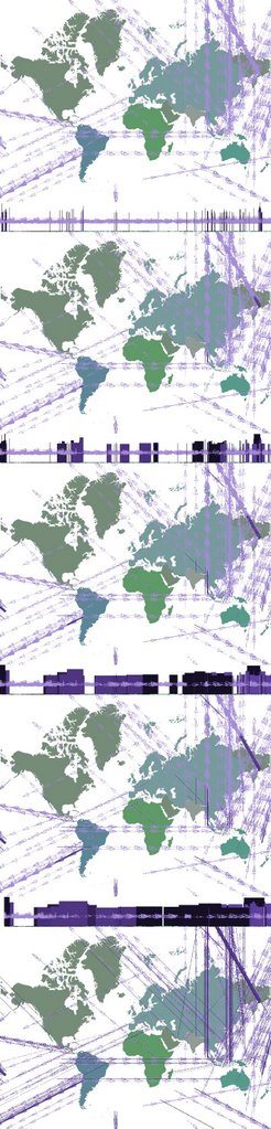
Earthquakes are much more common in specific areas than others, even along the fault lines. One expanation is that population density correlates with seismic occurance. High population and conscentration of buildings puts pressure on the earth and has been known to cause plate movements and earthquakes. The locations of the top 13 most populated cities in the world and their countries support this theory.

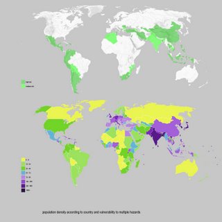
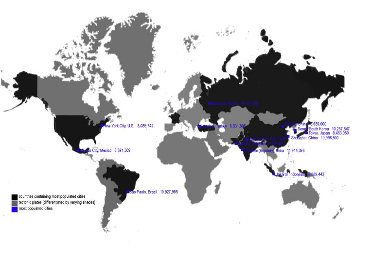
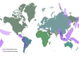
Not only risk of earthquakes, but risks of other natural disasters or phenomenons have an apparent correlation with population. Here you can see the comparison of countries that are vulnerable to more than one hazard, whether risk of hydro, drought, or geophysical, and the population density by country. This is apparent even when looking at countries alone.

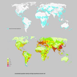
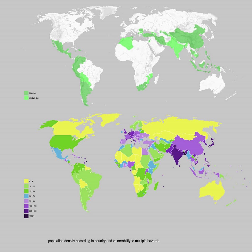
Here the risks and population density are pinpointed for exact locations of risk occurance and more accurate population numbers.

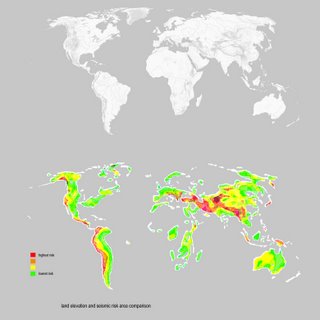
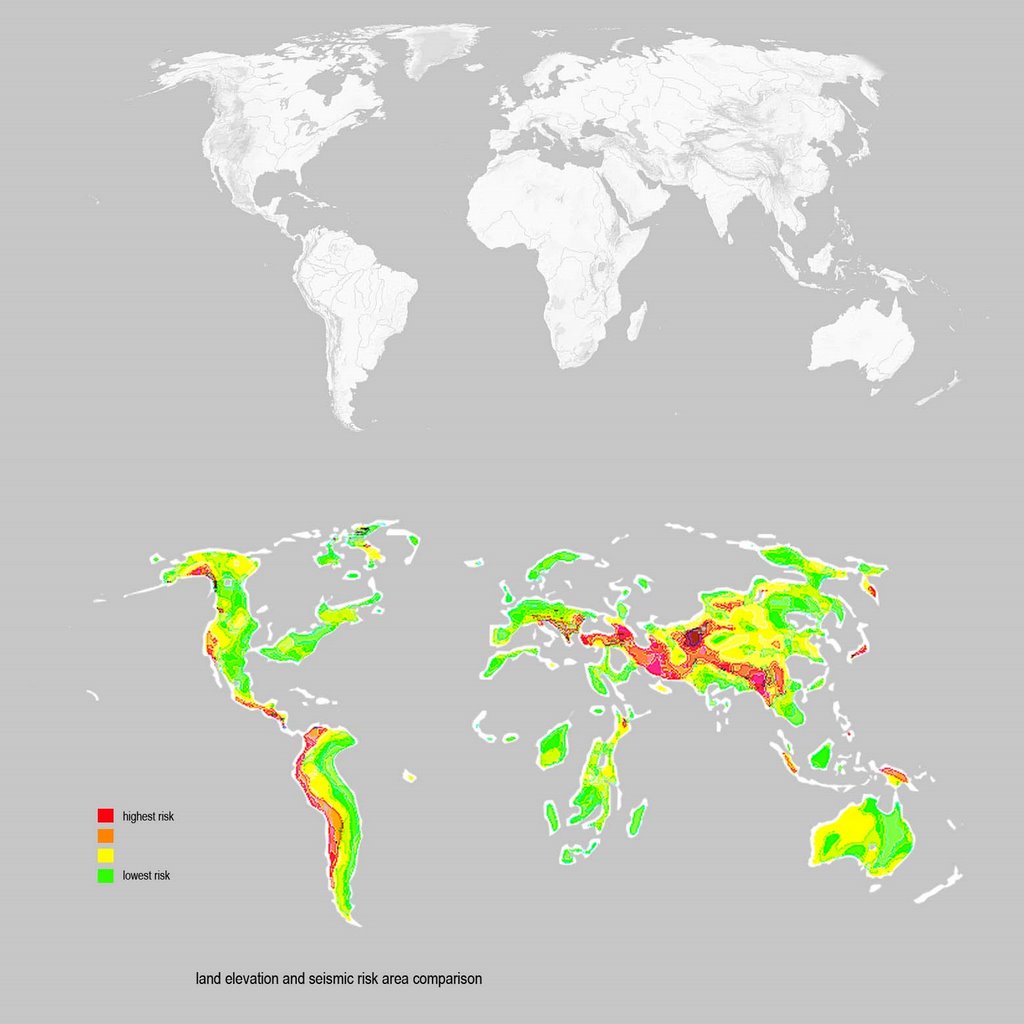
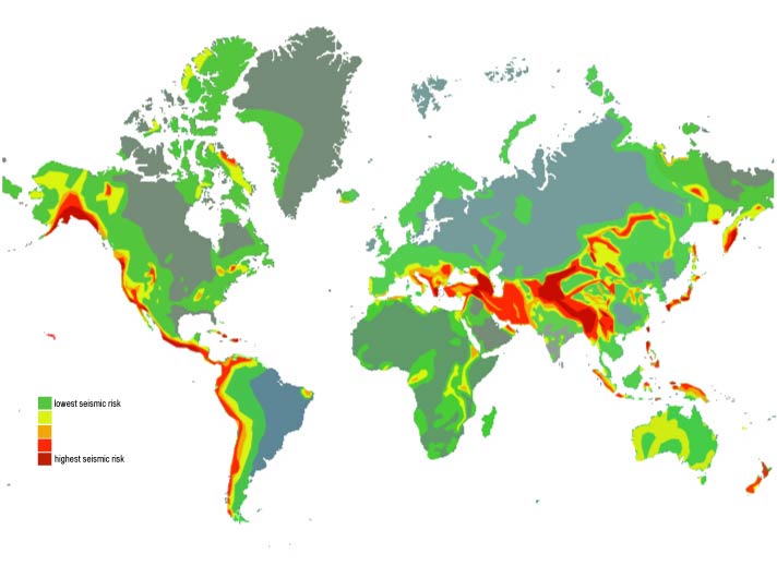
Another theory, taken from Pangaea, is that mountains and valleys are created or were created by the movement of the tectonic plates. In comparing the occurances of earthquakes to the elevation map, you can see that where there is the highest seismic risk, there usually lies a mountain range, a coastline, or both. In the ocean, ridges and trenches are formed, although these are not apparent at ground level. Earthquakes that occur along the fault lines located in the oceans can cause tsunamis and changes of elevation. These highs and lows are representative of the collision and separation of the plates over a long period of time.

[This image shows an overlay of global risks and vulnerabilty]

The direction of the constant plate movement is apparent and time causes these conditions to intersect. Frequency and density of the earthquakes create masses that are the beginnings of a new world.

My proposal for a new world begins to be shaped from my earthquake mappings conscentrating focus on areas of highest seismic risk. Based on the patterns shown in the maps, earthquakes were more prevelant and had more impact in these areas. Seismic cities could be built in existing areas of risk and new seismic cities could be built in the intersections of earthquake planes. These cities would be constructed with lightweight and economical materials to resist forming great pressures on the earth. Population in these areas could grow specifically in the new cities, as the old cities would be redesigned.