EARTHQUAKE RISK
Earthquakes are known to occur mostly along fault lines, which are the edges of the earth's tectonic plates. These sections, large and small, of the earth's crust shift at approximately the same rate that your fingernails grow in one year. Along the fault lines, earthquakes are bound to occur and very frequently because of their uncontrolable and constant motion. Earthquakes form our mountains and create valleys, even at the bottom of the ocean (of course this process has occured over a long period of time). Small earthquakes can move the plates millimeters at a time, where a single large earthquakes can move the earth's crust one or two meters. The positions of continents in our world today are beleived to have drifted from the supercontinent, also known as Pangaea, and settled somewhat permanently into their current positions.

Earthquakes are much more common in specific areas than others, even along the fault lines, where they are most prevailent. High population and conscentration of buildings puts pressure on the earth and has been known to cause plate movements and earthquakes. For example, Taipei 101, the tallest building in Tokyo [at more than 500 meters] is beleived to have reopened an old fault line. Speculation says that the building has caused two earthquakes since it's construction due to the 700,000 tons of stress that the building puts on the earth. Recently, an earthquake was provoked by engineers attempting to extract geothermal heat from deep inside the earth. They stopped their experiment in Zurich due to the fact that their "drilling" caused an earthquake [magnitude 3.4] in nearby Basil, Switzerland. Although population may not directly cause earthquake activity, megacities and megastructures can certainly trigger a quake.
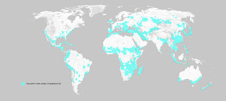
About 1/3 of the world's megacities [cities with a population of 2 million or more] are located near fault lines. Of the 13 most populated cities in the world, 10 are located in areas of high risk for earthquakes alone. However, it is purely coinsidence that populated placed along the coast, an aesthetically pleasing and popular location [frequently in high demand], lie parallel to fault lines. This idea follows along the same lines as the theory of the supercontinent, seeing that a land mass, once a single intity, broke apart creating new coastline along the fault lines [edges of the today's tectonic plates].
These areas are subject to repeat seismic activities and damages from earthquakes that have occured and will continue to occur. It is ironic that fault lines double as popular areas prone to urban growth and development. Since these areas of risk are now heavily populated they receive the most destructive impacts from earthquakes due to damage and casualty.
Earthquakes occur several hundred times a day. Earthquakes are so powerful that they have been compared to their energy equivalents [other natural disasters, bombs, etc.] according to the destruction that they both ensue. Because of these disasters and the physical and economical damage that they cause, there are seismic monitors that record the earth's reverberations and can even predict future occurances. There are seismic monitoring stations located around the world to monitor these earthquakes as they occur and record the effects of the shock and aftershocks to come. This data can be viewed publically on certain educational websites such as www.iris.com. The quakes are measured using the Richter Magnitude Scale [1 - 9.9]. Since this technology can prevent casualties, but cannot prevent damage, warnings are the only way to avoid an earthquake. One of the factors that most contributes to damage after an earthquake is fire. [As if the damage from the actual earthquake weren't enough!]
MAPPING
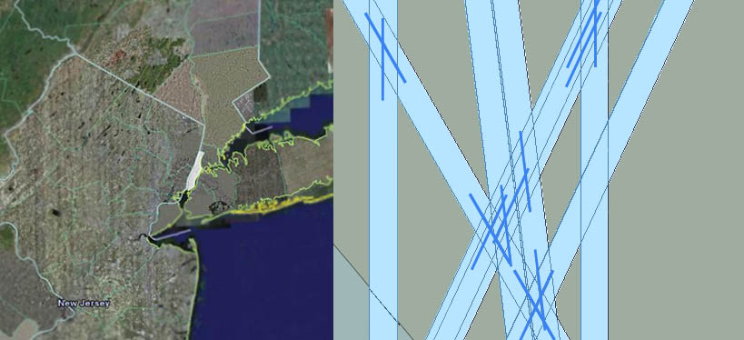
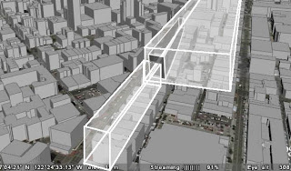
The mapping shows earthquake data which occurs over a period of 2 1/2 months, from April 15, 2006 - June 30, 2006. The fault lines, although not physically represented, start to appear by the earthquake patterns that occur over this short amount of time. Columns stand in the epicenter of each earthquake. [the height of the column representing the magnitude of the earthquake measured by the Richter Scale 1-9.9] These columns extend in a plane according to the directional movement of the tectonic plates at each specific location. The length of the axes is dependant on the amount of time that has passed since the earthquake occurred. The direction of the constant plate movement is apparent and time causes these conditions to intersect. Frequency and density of the earthquakes create masses that are the beginnings of a new world.
What if there was a way to construct or develop a city that embraces an earthquake instead of constructing to withstand the physical effects of a quake [like most cities]?
PROPOSAL
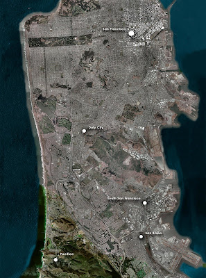
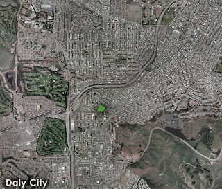
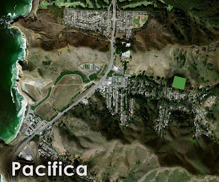
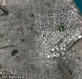
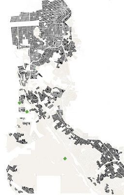
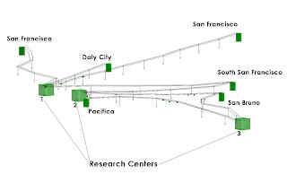
LOCATION : The San Andreas Fault. The fault, 1300 kilometers long, runs near the pacific coast from the west to the south of California. A right-lateral strike-slip fault, the San Andreas forms the boundary between two tectonic plates : the Pacific Plate and the North American Plate. Located in the San Francisco area, the San Andreas fault is surrounded by urban development. The cities in the San Francisco peninsula [and surrounding area] include : Daly City, Pacifica, San Bruno, San Francisco, and South San Francisco.
San Francisco is the second most densely populated city in the United States.
Because the San Andreas fault is a strike-slip fault, the city takes on these characteristics. This is an early collage of how components can slide and lock into other key structural components.


A Seismic City is a megacity located on or near a fault line [one that "cuts" through the land, not the ocean]. The Seismic City is constructed as a continuation and an improvement to a populated city that already exists and experiences earthquakes frequently or is located in a high risk area. The Seismic City is dedicated to research facilities, public aid, and seismic stations. The city monitors the movement under the earth's crust.
The cities begin to form from linear axes that parallel the direction of the tectonic plate movement at that specific location. One of the axes follows the path of the San Andreas fault on the left side, in the direction of the movement of the Pacific Plate. This axis consists of a series of three Research Centers. The other axis is -35 degrees, the direction of the North American Plate. All of the Earthquake Towers, which are the destinations for the Earthquake Complexes, are turned at this angle.
Seismic City is a proposal that a high-risk city embrace an earthquake as it occurs while also serving as a haven for research. After the 1906 San Francisco earthquake, 5,600 Earthquake Shacks were constructed to house approximately 16,000 of the people that had just become homeless. The proposal is derived from this concept of constructed housing units for relief, but units that are portable and ready-made.
COMPONENTS
1] Earthquake Complexes. These complexes leave the Research Centers upon detection of an earthquake occurance. When an earthquake strikes, the earthquake complexes are shipped to one or more stations in the city or cities nearest to the epicenter. They are stocked with damage supplies, first aid, vehicles to aid in moving debris, firetrucks, and ambulances. They also provide shelter for people that have been temporarily put out of a home. There are three different sizes of units that are sent out for earthquake relief depending on the magnitude of an earthquake. Whether it be a magnitude of 1-3, 3-6.5, or 6.5-9.9, three units of certain size are released from the Research Center.
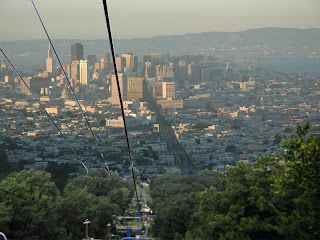
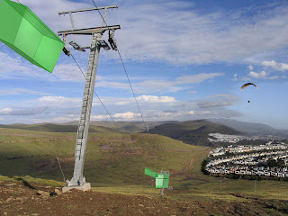
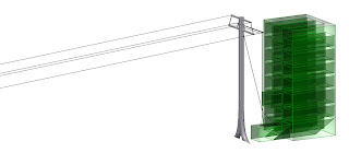
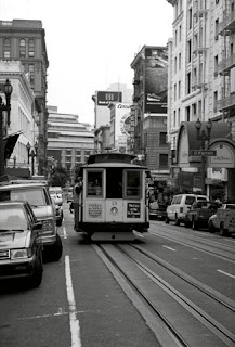
Transportation : The shacks are somewhat large buildings [comparable to an average low-rise commercial building] and are transported by cable. San Francisco is well-known for its use of cable cars throughout the city. They were first introduced in 1873 and are still used today. Although the earthquake shacks do not travel on the ground, the system is integrated into the city as they function similarly to ski-lifts. T-bar lifts, the most durable lifts, support the cables and allow easy transportation of the supply units. Earthquake Shacks slide in and out of the Research Centers on cables and are transported to their destination tower where they are locked in place.
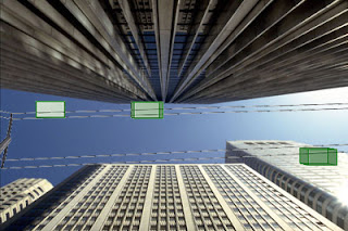

The city is a combination of static and dynamic components. The Earthquake Shacks are dynamic in movement from the Research Center to the Earthquake Tower. They are in transit while the earthquake is occuring. The Research Centers and the Earthquake Towers are both static.

2] Research Centers. There are three Research Centers aligned on the left side of the fault. These centers monitor seismic motion and project exaggerated vibrations and sounds during an earthquake. The centers project these sounds at an audible level. People that live in the city will be able to hear an earthquake as it occurs. Earthquake Shacks are manufactured and shipped from these locations. The Research Centers cover the span of eight city blocks [allowing for required space to manufacture the supply units].
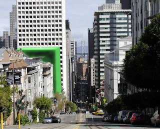
3] Earthquake Towers. At least one tower is located in every city surrounding the San Andreas fault. The tower is not only the destination of the Earthquake Shack, it becomes the permanent location. When a shack arrives, a "cradle" slides out of the tower from an available space. The shack is lowered onto the cradle from the cables above. The cradle then retracts into the tower, locking the unit in place. After the supplies have been used and people have been sheltered or treated, the shack remains in the tower becoming a permanent construction. The program of the unit can then change according to the needs of the city after the earthquake.